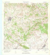
1960 Map of Coamo
USGS Topo · Published 1962About this map
The town of Coamo sits at the western edge of this 1960 landscape, surrounded by a complex network of quebradas and mountain ridges belonging to the Cordillera Central. The terrain is defined by its agricultural and military utility, where traditional landholdings like Hacienda Buena Vista and Hacienda Esmeralda represent the region's deep-rooted rural economy near Peñuelas. This map captures a moment of transition as the southeastern quadrant is dominated by the U. S. Military Reservation Salinas Training Area, showing how modern defense infrastructure carved into the older hills of Palmarejo and Jauca 2.
Find a feature on this map
57 named features on this map. Tap any name to fly to it.
Don’t see what you’re looking for? This feature index may not catch every label — zoom into the map to look around manually.
Map Details
Editions of this 1960 Coamo Map
2 editions found
Other maps of this area

1944 · Santa Isabel
USGS Topo · 1:30,000

1945 · Rio Descalabrado
USGS Topo · 1:30,000

1945 · Central Aguirre
USGS Topo · 1:30,000

1945 · Salinas
USGS Topo · 1:30,000

1946 · Coamo
USGS Topo · 1:30,000

1946 · Barranquitas
USGS Topo · 1:30,000

1946 · Cayey
USGS Topo · 1:30,000

1946 · Comerio
USGS Topo · 1:30,000

1946 · Orocovis
USGS Topo · 1:30,000

1947 · Cayey NO
USGS Topo · 1:10,000