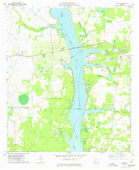
1977 Map of Cobb
USGS Topo · Published 1977About this map
Lake Blackshear dominates the landscape of this 1970s survey, marking the intersection of Sumter, Crisp, and Lee counties. The reservoir, formed by the impoundment of the Flint River, serves as the centerpiece for the Georgia Veterans Memorial State Park, which includes a campground and public facilities. The regional economy is anchored by the Seaboard Coast Line railroad, which bisects the terrain from east to west, passing through the small settlement of Cobb. Along the shores and surrounding rural lands, several claypits indicate localized extraction industries.
Find a feature on this map
27 named features on this map. Tap any name to fly to it.
Don’t see what you’re looking for? This feature index may not catch every label — zoom into the map to look around manually.
Map Details
Editions of this 1977 Cobb Map
2 editions found
Other maps of this area

1953 · Dothan
USGS Topo · 1:250,000

1953 · Waycross
USGS Topo · 1:250,000

1954 · Dothan
USGS Topo · 1:250,000

1955 · Dothan
USGS Topo · 1:250,000

1955 · Phenix City
USGS Topo · 1:250,000

1956 · Leslie
USGS Topo · 1:62,500

1957 · Phenix City
USGS Topo · 1:250,000

1957 · Macon
USGS Topo · 1:250,000

1958 · Macon
USGS Topo · 1:250,000

1958 · Phenix City
USGS Topo · 1:250,000