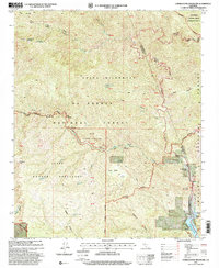
1995 Map of Cobblestone Mountain
USGS Topo · Published 2000About this map
Sespe Condor Sanctuary dominates this portion of the Los Padres National Forest, illustrating a landscape managed for conservation and wilderness. The 1995 revision reveals a remote network of trails and primitive camps, such as the Log Cabin Campsite and Ellis Apiary Campsite, situated along the winding drainage of Agua Blanca Creek. Evidence of earlier human activity is preserved in several noted locations, including the Hollister (Site) and the Whitaker Ranch (Site) near the Angeles National Forest boundary.
Find a feature on this map
52 named features on this map. Tap any name to fly to it.
Don’t see what you’re looking for? This feature index may not catch every label — zoom into the map to look around manually.
Map Details
Editions of this 1995 Cobblestone Mountain Map
This is the sole edition of this map. No revisions or reprints were ever made.
Other maps of this area

1900 · Piru
USGS Topo · 1:62,500

1903 · Tejon
USGS Topo · 1:125,000

1903 · Camulos
USGS Topo · 1:125,000

1903 · Santa Susana
USGS Topo · 1:62,500

1921 · Piru
USGS Topo · 1:62,500

1931 · Whitaker Peak
USGS Topo · 1:24,000

1931 · Santa Felicia Canyon
USGS Topo · 1:24,000

1932 · Beartrap Canyon
USGS Topo · 1:24,000

1935 · Santa Felicia Canyon
USGS Topo · 1:24,000

1935 · Whitaker Peak
USGS Topo · 1:24,000