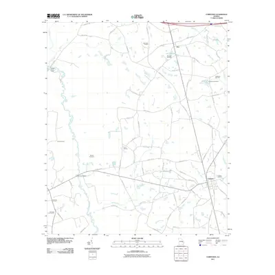
2011 Map of Cobbtown
USGS Topo · Published 2011About this map
The Ohoopee River meanders through the western portion of this Tattnall County landscape, punctuated by historic crossings such as Griffins Ferry Bridge and Coleman Bridge. The settlement of Cobbtown serves as a primary hub in the southeast, while the smaller community of Aline sits further north near the waters of Boatright Lake. This survey illustrates a rural Georgia topography defined by agricultural connectivity and water management, featuring several localized impoundments like Anderson Lake and Brown Pond. For those researching local family history, the map is a vital resource for locating traditional burial grounds scattered across the terrain, including the Old Reedy Creek Cemetery, Hebron Cemetery, and Oak Chapel Cemetery. The network of county roads documented here provides a detailed view of the rural infrastructure as it existed in the early 21st century.
Find a feature on this map
75 named features on this map. Tap any name to fly to it.
Don’t see what you’re looking for? This feature index may not catch every label — zoom into the map to look around manually.
Map Details
Editions of this 2011 Cobbtown Map
This is the sole edition of this map. No revisions or reprints were ever made.
Other maps of this area

1957 · Macon
USGS Topo · 1:250,000

1958 · Macon
USGS Topo · 1:250,000

1964 · Macon
USGS Topo · 1:250,000

1970 · Cobbtown
USGS Topo · 1:24,000
1970 · Collins
USGS Topo · 1:24,000
1970 · Metter
USGS Topo · 1:24,000
1970 · Metter SE
USGS Topo · 1:24,000

1970 · Nunez
USGS Topo · 1:24,000

1970 · Ohoopee
USGS Topo · 1:24,000

1970 · Lyons
USGS Topo · 1:24,000