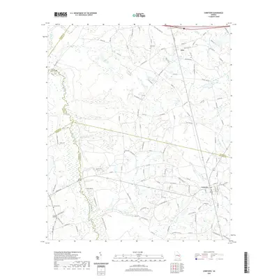
2020 Map of Cobbtown
USGS Topo · Published 2020About this map
The Ohoopee River and its dense network of tributaries, including Beaver Cr and Wolfe Cr, define the landscape of south-central Georgia near the intersection of Emanuel, Candler, Toombs, and Tattnall Counties. Rural life in the early 21st century is anchored by the small community of Cobbtown and the village of Aline, where numerous family and community burial grounds like Oak Chapel Cem, Findley Cem, and Hebron Cem provide a clear record of local lineage. The transport network relies on historical river crossings such as Griffins Ferry Bridge and Coleman Bridge, while land use is marked by agricultural developments like Beaver Creek Plantation Rd. Small water bodies, including Boatright Lake and Mac Wac Lake, dot the terrain between extensive creek bottomlands, illustrating a pattern of settlement closely tied to the region's hydrography.
Find a feature on this map
132 named features on this map. Tap any name to fly to it.
Don’t see what you’re looking for? This feature index may not catch every label — zoom into the map to look around manually.
Map Details
Editions of this 2020 Cobbtown Map
This is the sole edition of this map. No revisions or reprints were ever made.
Other maps of this area

1957 · Macon
USGS Topo · 1:250,000

1958 · Macon
USGS Topo · 1:250,000

1964 · Macon
USGS Topo · 1:250,000

1970 · Cobbtown
USGS Topo · 1:24,000
1970 · Collins
USGS Topo · 1:24,000
1970 · Metter
USGS Topo · 1:24,000
1970 · Metter SE
USGS Topo · 1:24,000

1970 · Nunez
USGS Topo · 1:24,000

1970 · Ohoopee
USGS Topo · 1:24,000

1970 · Lyons
USGS Topo · 1:24,000