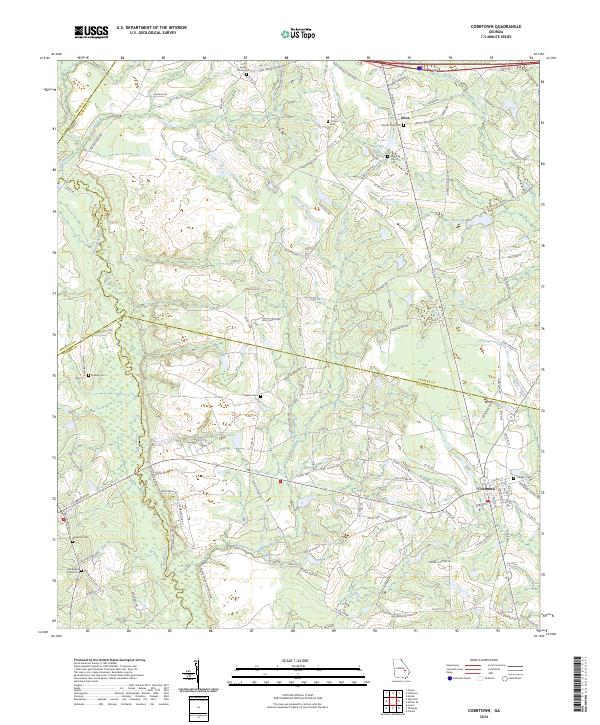
2024 Map of Cobbtown
USGS Topo · Published 2024About this map
Cobbtown and Aline anchor this landscape along the borders of Tattnall, Candler, Toombs, and Emanuel counties. The terrain is defined by a complex network of waterways, including the winding Ohoopee River and the Canoochee River in the northeast corner. This modern survey illustrates how long-established rural centers persist through their community landmarks. Numerous burial grounds such as Bazemore Cem, Hebron Cem, and Sunlight Cem are scattered across the quadrangle, serving as vital touchstones for genealogical research in the Georgia coastal plain. Notable local congregations like Oak Chapel and Cool Spring Church remain central to the settlement pattern, while named natural features like Thumper Hollow and Brown Pond break the primarily agricultural and wooded stretches of the region. The map also traces the drainage systems of Beaver Creek and Wolfe Creek, which feed into the area's larger river basins.
Find a feature on this map
131 named features on this map. Tap any name to fly to it.
Don’t see what you’re looking for? This feature index may not catch every label — zoom into the map to look around manually.
Map Details
Editions of this 2024 Cobbtown Map
This is the sole edition of this map. No revisions or reprints were ever made.
Other maps of this area

1957 · Macon
USGS Topo · 1:250,000

1958 · Macon
USGS Topo · 1:250,000

1964 · Macon
USGS Topo · 1:250,000

1970 · Cobbtown
USGS Topo · 1:24,000
1970 · Collins
USGS Topo · 1:24,000
1970 · Metter
USGS Topo · 1:24,000
1970 · Metter SE
USGS Topo · 1:24,000

1970 · Nunez
USGS Topo · 1:24,000

1970 · Ohoopee
USGS Topo · 1:24,000

1970 · Lyons
USGS Topo · 1:24,000