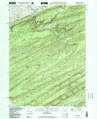
1998 Map of Coburn
USGS Topo · Published 1999About this map
Penns Creek and Elk Creek converge at the village of Coburn, a focal point of settlement in this landscape dominated by the ridges of the Bald Eagle State Forest. The village is anchored by St Johns Ch and Trinity Ch, while the Penn Central rail line follows the winding watercourse through the gaps. South of the main settlement, the terrain transitions into the protected enclave of Poe Valley State Park, which includes campgrounds near the headwaters of Poe Creek. The map documents a complex ridge-and-valley system where family-named landmarks like Rupp Mountain and Woodward Mtn define local geography. Deep within these ridges, features such as Havice Spring and the Salem Cem reflect a history of remote mountain living along the Centre and Mifflin County line.
Find a feature on this map
76 named features on this map. Tap any name to fly to it.
Don’t see what you’re looking for? This feature index may not catch every label — zoom into the map to look around manually.
Map Details
Editions of this 1998 Coburn Map
This is the sole edition of this map. No revisions or reprints were ever made.
Other maps of this area

1924 · Centre Hall
USGS Topo · 1:62,500

1924 · Lewistown
USGS Topo · 1:62,500

1925 · Mifflintown
USGS Topo · 1:48,000

1927 · Lewisburg
USGS Topo · 1:62,500

1929 · Centre Hall
USGS Topo · 1:62,500

1934 · Mifflintown
USGS Topo · 1:62,500

1937 · Mifflintown
USGS Topo · 1:62,500

1937 · Millheim
USGS Topo · 1:48,000

1941 · Millheim
USGS Topo · 1:62,500

1943 · Lewistown
USGS Topo · 1:125,000