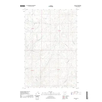
2020 Map of Cody Lake
USGS Topo · Published 2020About this map
Cody Lake and the high, forested drainage basins of eastern Washington define this landscape within the Colville Indian Reservation. The map shows a complex network of Bureau of Indian Affairs routes and historic pack trails, such as the Thirtymile Creek-Keno Trl and the Twin Lakes Summit Trl, which follow the contours of the Kettle River Range. Numerous creeks, including Twentythree Mile Cr, Lynx Cr, and Klondyke Cr, carve deep valleys through the terrain. These watercourses and their associated ridges, like the one carrying Oregon City Ridge Rd, illustrate the long-standing importance of high-country access for timber management and traditional land use. Regional connectivity is maintained via the Red Thunder Cutoff and Co Hwy 2 in the southern portion of the quadrangle.
Find a feature on this map
25 named features on this map. Tap any name to fly to it.
Don’t see what you’re looking for? This feature index may not catch every label — zoom into the map to look around manually.
Map Details
Editions of this 2020 Cody Lake Map
This is the sole edition of this map. No revisions or reprints were ever made.
Other maps of this area

1948 · Wilmont Creek
USGS Topo · 1:62,500

1950 · Wilmont Creek
USGS Topo · 1:62,500

1952 · Keller
USGS Topo · 1:62,500

1952 · Twin Lakes
USGS Topo · 1:62,500

1953 · Seventeenmile Mtn.
USGS Topo · 1:62,500

1954 · Okanogan
USGS Topo · 1:250,000

1956 · Wilmont Creek
USGS Topo · 1:62,500

1958 · Okanogan
USGS Topo · 1:250,000

1984 · Nespelem
USGS Topo · 1:100,000
1985 · Sitdown Mtn
USGS Topo · 1:24,000