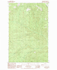
1985 Map of Sitdown Mtn
USGS Topo · Published 1985About this map
The Colville Indian Reservation and Colville National Forest dominate this northeastern Washington landscape, where the administrative boundary cuts across the high country of Ferry County. Central to the map is the massive profile of Sitdown Mountain, flanked by a network of drainages including Onion Creek, Hall Creek, and Grizzly Creek. The terrain is characterized by prominent ridgelines such as Onion Ridge and Buckhorn Ridge, which provided the framework for early forest service activity and recreation. Public land use is marked by the presence of the Buckhorn Creek Campground and the CCC Campground, the latter reflecting the labor legacy of the Civilian Conservation Corps in the Pacific Northwest. Surveyed in the early 1980s, the map documents a transition from the higher peaks like Buckhorn Mtn and Grizzly Mountain down into the narrow, winding creek valleys that defined the area's timber and grazing history.
Find a feature on this map
22 named features on this map. Tap any name to fly to it.
Don’t see what you’re looking for? This feature index may not catch every label — zoom into the map to look around manually.
Map Details
Editions of this 1985 Sitdown Mtn Map
2 editions found
Other maps of this area

1904 · Republic
USGS Topo · 1:125,000

1936 · Marcus
USGS Topo · 1:96,000

1942 · Marcus
USGS Topo · 1:125,000

1948 · Republic
USGS Topo · 1:62,500

1948 · Sherman Peak
USGS Topo · 1:62,500

1951 · Sherman Peak
USGS Topo · 1:62,500

1951 · Republic
USGS Topo · 1:62,500

1952 · Twin Lakes
USGS Topo · 1:62,500

1953 · Seventeenmile Mtn.
USGS Topo · 1:62,500

1954 · Okanogan
USGS Topo · 1:250,000