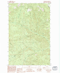
1985 Map of Sitdown Mtn.
USGS Topo · Published 1994About this map
The Colville Indian Reservation boundary defines the southern half of this landscape, where the terrain rises toward the prominent heights of Sitdown Mountain and Johns Mountain. To the north, the Colville National Forest encompasses a series of steep drainages and prominent ridges including Onion Ridge and Buckhorn Ridge. This 1985 survey illustrates the recreational development of the era, marking the Buckskin Creek Campground and the CCC Campground along the winding course of Hall Creek. The topography is defined by significant elevations like Grizzly Mountain and Lynx Mountain, which overlook a network of seasonal streams such as Sleepy Hollow Creek and Sitdown Creek. The map provides a clear record of the jurisdictional division between federal forest lands and tribal reservation territory in the mountains of Ferry County.
Find a feature on this map
21 named features on this map. Tap any name to fly to it.
Don’t see what you’re looking for? This feature index may not catch every label — zoom into the map to look around manually.
Map Details
Editions of this 1985 Sitdown Mtn. Map
2 editions found
Other maps of this area

1904 · Republic
USGS Topo · 1:125,000

1936 · Marcus
USGS Topo · 1:96,000

1942 · Marcus
USGS Topo · 1:125,000

1948 · Republic
USGS Topo · 1:62,500

1948 · Sherman Peak
USGS Topo · 1:62,500

1951 · Sherman Peak
USGS Topo · 1:62,500

1951 · Republic
USGS Topo · 1:62,500

1952 · Twin Lakes
USGS Topo · 1:62,500

1953 · Seventeenmile Mtn.
USGS Topo · 1:62,500

1954 · Okanogan
USGS Topo · 1:250,000