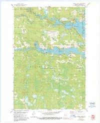
1978 Map of Coffee Creek
USGS Topo · Published 1991About this map
Lake Mohawksin and the convergence of the Somo River and Spirit River Flowage dominate this late 1970s topographical record of Lincoln County. The map details the industrial and transportation infrastructure surrounding Tomahawk, where the Marinette Tomahawk and Western railroad tracks navigate the complex shoreline near West Kraft and the Cranberry Bog. Further west, the landscape transitions into managed forests and rural landmarks such as the Wilson School and the Zenith Lookout Tower, which served as a critical fire watch point for the timber-rich Wilson and Tomahawk townships. Local transit is traced through named corridors like Zenith Tower Road and the Old Railroad Grade, reflecting the area's history of logging and rail development. From the Jersey City Flowage to the Tomahawk Regional Airport, the survey documents a region defined by its reliance on water power and wood products.
Find a feature on this map
38 named features on this map. Tap any name to fly to it.
Don’t see what you’re looking for? This feature index may not catch every label — zoom into the map to look around manually.
Map Details
Editions of this 1978 Coffee Creek Map
2 editions found
Other maps of this area

1939 · Mc Cord
USGS Topo · 1:48,000

1939 · Cassian
USGS Topo · 1:48,000

1942 · Cassian
USGS Topo · 1:48,000

1947 · Mc Cord
USGS Topo · 1:48,000

1950 · Tomahawk
USGS Topo · 1:48,000

1950 · Spirit Falls
USGS Topo · 1:48,000

1952 · Spirit Falls
USGS Topo · 1:48,000

1952 · Tomahawk
USGS Topo · 1:48,000

1954 · Iron Mountain
USGS Topo · 1:250,000

1959 · Iron Mountain
USGS Topo · 1:250,000