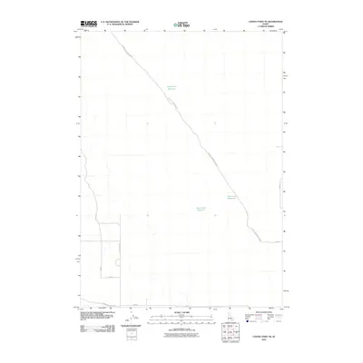
2010 Map of Coffee Point NE
USGS Topo · Published 2010About this map
Big Butte Springfield Rd cuts a diagonal path through this arid high-desert landscape in Bingham County, serving as the primary corridor for a region defined by scattered water management and sparse rural infrastructure. The 2010 topography shows a network of reservoirs including Camp Four Reservoir, Sheep Lake Reservoir, and Duck Lake Reservoir, which are vital nodes in an otherwise dry terrain. This drainage and storage system, coupled with a rigid grid of section roads like N Powerline Rd and Springfield Mosby Rd in the southwest corner, reflects the intensive land management required for agriculture and ranching in eastern Idaho. The map captures a transition where the organized township and range grid meets the more irregular paths of early access roads following the natural contours of the plain.
Find a feature on this map
12 named features on this map. Tap any name to fly to it.
Don’t see what you’re looking for? This feature index may not catch every label — zoom into the map to look around manually.
Map Details
Editions of this 2010 Coffee Point NE Map
This is the sole edition of this map. No revisions or reprints were ever made.
Other maps of this area

1955 · Springfield NW
USGS Topo · 1:24,000

1955 · Springfield
USGS Topo · 1:24,000

1955 · Idaho Falls
USGS Topo · 1:250,000

1958 · Idaho Falls
USGS Topo · 1:250,000

1973 · Taber
USGS Topo · 1:24,000

1973 · Rock Butte
USGS Topo · 1:24,000
1973 · Coffee Point SW
USGS Topo · 1:24,000

1973 · Lava Lake Reservoir
USGS Topo · 1:24,000

1973 · Coffee Point NE
USGS Topo · 1:24,000
1973 · Coffee Point
USGS Topo · 1:24,000