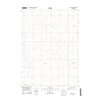
2013 Map of Coffee Point NE
USGS Topo · Published 2013About this map
Hydraulic management defines this landscape in southern Idaho, where several catchment basins are situated amidst the sectioned high desert. The presence of Sheep Lake Reservoir, Duck Lake Reservoir, and Camp Four Reservoir points to the essential role of water storage in this arid region, likely supporting local agriculture or livestock. A grid-based transportation network, including Springfield Mosby Rd and N Powerline Rd, underscores the systematic surveying and land use management in Bingham County. The terrain is characterized by subtle elevation changes and depressions, with local landmarks like 300 S Rd providing the primary orientation points for travelers and residents in this sparse portion of the Snake River Plain.
Find a feature on this map
15 named features on this map. Tap any name to fly to it.
Don’t see what you’re looking for? This feature index may not catch every label — zoom into the map to look around manually.
Map Details
Editions of this 2013 Coffee Point NE Map
This is the sole edition of this map. No revisions or reprints were ever made.
Other maps of this area

1955 · Springfield NW
USGS Topo · 1:24,000

1955 · Springfield
USGS Topo · 1:24,000

1955 · Idaho Falls
USGS Topo · 1:250,000

1958 · Idaho Falls
USGS Topo · 1:250,000

1973 · Taber
USGS Topo · 1:24,000

1973 · Rock Butte
USGS Topo · 1:24,000
1973 · Coffee Point SW
USGS Topo · 1:24,000

1973 · Lava Lake Reservoir
USGS Topo · 1:24,000

1973 · Coffee Point NE
USGS Topo · 1:24,000
1973 · Coffee Point
USGS Topo · 1:24,000