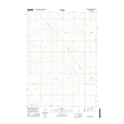
2017 Map of Coffee Point NE
USGS Topo · Published 2017About this map
Camp Four Reservoir and Duck Lake Reservoir anchor the high desert landscape of Bingham County in this 2017 study. The region is defined by a sparse network of section roads and reservoirs, reflecting the agricultural and water management needs of Idaho’s Snake River Plain. The primary thoroughfare, Big Butte Springfield Rd, cuts diagonally across the terrain, connecting the area to surrounding rural hubs. Local travel is facilitated by a grid of numbered roads including 300 S Rd, S 2800 W, and 2300 W Rd. Other significant water features like Sheep Lake Reservoir emphasize the importance of artificial basins in this arid environment. The map provides a look at the modern land divisions near the southern end of the Idaho National Laboratory vicinity, bounded by routes such as Springfield Mosby Rd and Coffee Point Rd.
Find a feature on this map
14 named features on this map. Tap any name to fly to it.
Don’t see what you’re looking for? This feature index may not catch every label — zoom into the map to look around manually.
Map Details
Editions of this 2017 Coffee Point NE Map
This is the sole edition of this map. No revisions or reprints were ever made.
Other maps of this area

1955 · Springfield NW
USGS Topo · 1:24,000

1955 · Springfield
USGS Topo · 1:24,000

1955 · Idaho Falls
USGS Topo · 1:250,000

1958 · Idaho Falls
USGS Topo · 1:250,000

1973 · Taber
USGS Topo · 1:24,000

1973 · Rock Butte
USGS Topo · 1:24,000
1973 · Coffee Point SW
USGS Topo · 1:24,000

1973 · Lava Lake Reservoir
USGS Topo · 1:24,000

1973 · Coffee Point NE
USGS Topo · 1:24,000
1973 · Coffee Point
USGS Topo · 1:24,000