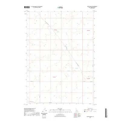
2020 Map of Coffee Point NE
USGS Topo · Published 2020About this map
Camp Four Reservoir and Sheep Lake Reservoir anchor this arid stretch of Bingham County, where water management is central to the high desert landscape. The map reveals a systematic grid of land divisions across township T2S R31E and surrounding sections, intersected by specialized transport routes such as Big Butte Springfield Rd and Springfield Mosby Rd. These roads suggest a landscape dedicated to large-scale ranching or agricultural operations, connecting remote watering holes like Duck Lake Reservoir to the wider region. The placement of Coffee Point Rd and 300 South Rd underscores the organized settlement pattern that defines this part of Idaho, providing a clear view of the rural infrastructure as it stood in the early 21st century.
Find a feature on this map
14 named features on this map. Tap any name to fly to it.
Don’t see what you’re looking for? This feature index may not catch every label — zoom into the map to look around manually.
Map Details
Editions of this 2020 Coffee Point NE Map
This is the sole edition of this map. No revisions or reprints were ever made.
Other maps of this area

1955 · Springfield NW
USGS Topo · 1:24,000

1955 · Springfield
USGS Topo · 1:24,000

1955 · Idaho Falls
USGS Topo · 1:250,000

1958 · Idaho Falls
USGS Topo · 1:250,000

1973 · Taber
USGS Topo · 1:24,000

1973 · Rock Butte
USGS Topo · 1:24,000
1973 · Coffee Point SW
USGS Topo · 1:24,000

1973 · Lava Lake Reservoir
USGS Topo · 1:24,000

1973 · Coffee Point NE
USGS Topo · 1:24,000
1973 · Coffee Point
USGS Topo · 1:24,000