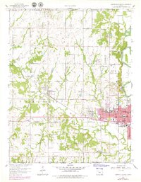
1959 Map of Coffeyville West
USGS Topo · Published 1979About this map
The Verdigris River snakes along the eastern edge of this landscape, framing the industrial and residential growth of Coffeyville as it appeared during the mid-to-late twentieth century. The map documents the urban expansion into West Coffeyville, while the surrounding countryside remains dotted with the symbols of an earlier agricultural era. Numerous schools such as Pierson Sch and Cedar Bluff Sch alongside country churches like Wesley Chapel and Spring Hill Ch reveal the established rural community structure.
Find a feature on this map
51 named features on this map. Tap any name to fly to it.
Don’t see what you’re looking for? This feature index may not catch every label — zoom into the map to look around manually.
Map Details
Editions of this 1959 Coffeyville West Map
2 editions found
Other maps of this area

1886 · Independence
USGS Topo · 1:125,000

1894 · Independence
USGS Topo · 1:125,000

1901 · Nowata
USGS Topo · 1:125,000

1905 · Independence
USGS Topo · 1:125,000

1914 · Nowata
USGS Topo · 1:125,000

1947 · Joplin
USGS Topo · 1:250,000

1949 · Joplin
USGS Topo · 1:250,000

1954 · Tulsa
USGS Topo · 1:250,000

1954 · Joplin
USGS Topo · 1:250,000

1958 · Joplin
USGS Topo · 1:250,000