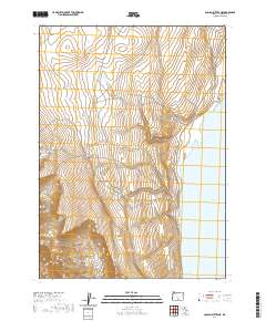
2020 Map of Coglan Buttes NE
USGS Topo · Published 2020About this map
Lake Abert dominates the eastern edge of this Lake County landscape, its broad waters set against the sharp relief of the surrounding rimrock. This area of south-central Oregon is defined by the stark verticality of the Coglan Canyon system, where the terrain rises abruptly from the alkaline lake basin. The 2020 survey clearly illustrates the geographic transition between the high desert shoreline and the upland plateaus, providing a precise record of the public land survey system across Townships 32 through 34 South. The absence of developed settlements or improved roads highlights the character of this high-elevation basin, where the landscape is shaped primarily by fault-block geology and seasonal water cycles.
Find a feature on this map
8 named features on this map. Tap any name to fly to it.
Don’t see what you’re looking for? This feature index may not catch every label — zoom into the map to look around manually.
Map Details
Editions of this 2020 Coglan Buttes NE Map
This is the sole edition of this map. No revisions or reprints were ever made.
Other maps of this area

1955 · Klamath Falls
USGS Topo · 1:250,000

1958 · Klamath Falls
USGS Topo · 1:250,000

1966 · Coglan Buttes NE
USGS Topo · 1:24,000

1966 · Tucker Hill
USGS Topo · 1:24,000

1966 · Coglan Buttes SE
USGS Topo · 1:24,000

1966 · Coglan Buttes
USGS Topo · 1:24,000

1968 · Lake Abert North
USGS Topo · 1:24,000

1968 · Lake Abert South
USGS Topo · 1:24,000

1974 · Lake Abert
USGS Topo · 1:100,000
1984 · Sawed Horn
USGS Topo · 1:24,000