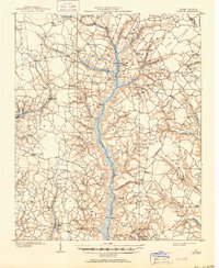
1909 Map of Coharie
USGS Topo · Published 1950About this map
Great Coharie Creek and Little Coharie Creek dominate this coastal plain landscape, their wide swampy basins dictating the placement of settlements and river crossings at the turn of the century. Surveyed between 1906 and 1907, the map reveals a decentralized agricultural society connected by a network of named junctions and family-owned establishments. Rural crossroads such as McClam Crossroads, Herrings Crossroads, and Munks Crossroads served as vital community anchors alongside local commerce centers like Brewers Store and Wilsons Store.
Find a feature on this map
70 named features on this map. Tap any name to fly to it.
Don’t see what you’re looking for? This feature index may not catch every label — zoom into the map to look around manually.
Map Details
Editions of this 1909 Coharie Map
3 editions found
Other maps of this area

1906 · Four Oaks
USGS Topo · 1:48,000

1908 · Four Oaks
USGS Topo · 1:62,500

1909 · Coharie
USGS Topo · 1:62,500

1953 · Florence
USGS Topo · 1:250,000

1953 · Raleigh
USGS Topo · 1:250,000

1954 · Florence
USGS Topo · 1:250,000

1954 · Raleigh
USGS Topo · 1:250,000

1959 · Roseboro
USGS Topo · 1:62,500

1959 · Garland
USGS Topo · 1:62,500

1962 · Rose Hill
USGS Topo · 1:62,500