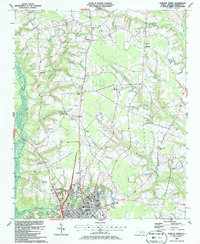
1986 Map of Clinton North
USGS Topo · Published 1986About this map
The northern reaches of Clinton serve as a hub for this Sampson County landscape, where the transition from suburban development to agricultural land is marked by the presence of the Sampson Co Mem Hospital and the N C Division of Prisons (Sampson Unit). The city's northern edge is dotted with civic and commercial markers of the mid-1980s, including a Shopping Center, the local Armory, and a Drive-in Theater. Beyond the city limits, the terrain is defined by a dense network of watercourses, most notably Six Runs Creek and Great Coharie Creek.
Find a feature on this map
37 named features on this map. Tap any name to fly to it.
Don’t see what you’re looking for? This feature index may not catch every label — zoom into the map to look around manually.
Map Details
Editions of this 1986 Clinton North Map
This is the sole edition of this map. No revisions or reprints were ever made.
Other maps of this area

1909 · Coharie
USGS Topo · 1:62,500

1953 · Florence
USGS Topo · 1:250,000

1953 · Raleigh
USGS Topo · 1:250,000

1954 · Florence
USGS Topo · 1:250,000

1954 · Raleigh
USGS Topo · 1:250,000

1959 · Garland
USGS Topo · 1:62,500

1962 · Rose Hill
USGS Topo · 1:62,500

1975 · Faison
USGS Topo · 1:24,000
1978 · Dobbersville
USGS Topo · 1:24,000

1982 · Elizabethtown
USGS Topo · 1:100,000