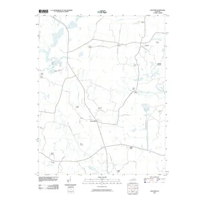
2010 Map of Coiltown
USGS Topo · Published 2010About this map
The western coalfields of Hopkins County are defined by a landscape of resource extraction and scattered rural settlements. In this 2010 survey, the area around Coiltown and Coiltown Junction shows the intensive footprint of the mining industry, with sites like the Coiltown Mine, Yarbrough Mine, and the Stoney Point Mine marking the terrain. The presence of the Kirkwood Springs Gas Field further underscores the energy-driven economy of the region.
Find a feature on this map
54 named features on this map. Tap any name to fly to it.
Don’t see what you’re looking for? This feature index may not catch every label — zoom into the map to look around manually.
Map Details
Editions of this 2010 Coiltown Map
This is the sole edition of this map. No revisions or reprints were ever made.
Other maps of this area

1907 · Earlington
USGS Topo · 1:48,000

1908 · Princeton
USGS Topo · 1:62,500

1909 · Dawson Springs
USGS Topo · 1:48,000

1909 · Earlington
USGS Topo · 1:62,500

1909 · Providence
USGS Topo · 1:62,500

1910 · Princeton
USGS Topo · 1:62,500

1911 · Dawson Springs
USGS Topo · 1:62,500

1954 · Evansville
USGS Topo · 1:250,000
1954 · Nebo
USGS Topo · 1:24,000
1954 · Providence
USGS Topo · 1:24,000