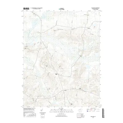
2016 Map of Coiltown
USGS Topo · Published 2016About this map
Coiltown and the surrounding Hopkins County countryside are defined by a network of rural ridges and creek valleys that have shaped local settlement for generations. The landscape is punctuated by family and community landmarks, from the Watson Bridge crossing Clear Creek to the numerous burial grounds like Old Beulah Cem and Irving Howton Cem that serve as vital touchpoints for genealogical research. The map illustrates a pattern of small upland communities such as Rabbit Ridge, Beulah, and the distinctly named Fiddle Bow, many connected by narrow lanes bearing family names like Fergusontown Rd and Paul Peyton Rd. The presence of Sixth Vein points to the region's coal mining heritage, while extensive wetlands along Pond Creek and Rose Cr reveal the natural drainage patterns of the western Kentucky coalfields.
Find a feature on this map
57 named features on this map. Tap any name to fly to it.
Don’t see what you’re looking for? This feature index may not catch every label — zoom into the map to look around manually.
Map Details
Editions of this 2016 Coiltown Map
This is the sole edition of this map. No revisions or reprints were ever made.
Other maps of this area

1907 · Earlington
USGS Topo · 1:48,000

1908 · Princeton
USGS Topo · 1:62,500

1909 · Dawson Springs
USGS Topo · 1:48,000

1909 · Earlington
USGS Topo · 1:62,500

1909 · Providence
USGS Topo · 1:62,500

1910 · Princeton
USGS Topo · 1:62,500

1911 · Dawson Springs
USGS Topo · 1:62,500

1954 · Evansville
USGS Topo · 1:250,000
1954 · Nebo
USGS Topo · 1:24,000
1954 · Providence
USGS Topo · 1:24,000