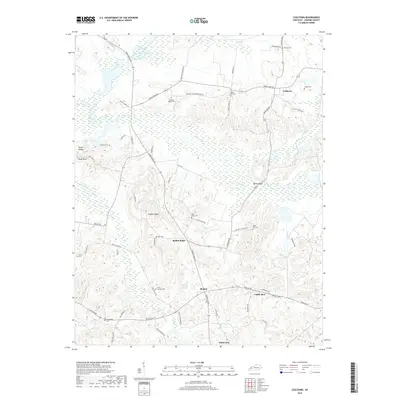
2019 Map of Coiltown
USGS Topo · Published 2019About this map
Pond Creek and Clear Creek dominate the low-lying wetlands of northern Hopkins County, shaping the settlement patterns of this rural landscape. These drainage basins separate the rolling uplands where small communities like Coiltown and Rabbit Ridge are situated. The map provides a detailed view of a landscape defined by localized family and community landmarks, evidenced by the high density of small cemeteries such as Rose Creek Cem, Johnson Island Cem, and the Irving Howton Cem south of Beulah.
Find a feature on this map
65 named features on this map. Tap any name to fly to it.
Don’t see what you’re looking for? This feature index may not catch every label — zoom into the map to look around manually.
Map Details
Editions of this 2019 Coiltown Map
This is the sole edition of this map. No revisions or reprints were ever made.
Other maps of this area

1907 · Earlington
USGS Topo · 1:48,000

1908 · Princeton
USGS Topo · 1:62,500

1909 · Dawson Springs
USGS Topo · 1:48,000

1909 · Earlington
USGS Topo · 1:62,500

1909 · Providence
USGS Topo · 1:62,500

1910 · Princeton
USGS Topo · 1:62,500

1911 · Dawson Springs
USGS Topo · 1:62,500

1954 · Evansville
USGS Topo · 1:250,000
1954 · Nebo
USGS Topo · 1:24,000
1954 · Providence
USGS Topo · 1:24,000