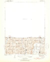
1940 Map of Coin
USGS Topo · Published 1954About this map
Blanchard, Braddyville, Elmo, and Clearmont anchor this survey of the borderlands between Page County, Iowa, and Nodaway and Atchison Counties, Missouri. The landscape is defined by the parallel courses of the Tarkio River and the Nodaway River, with the Wabash and Chicago Burlington and Quincy railroads providing the essential transportation corridors for these agricultural communities.
Find a feature on this map
42 named features on this map. Tap any name to fly to it.
Don’t see what you’re looking for? This feature index may not catch every label — zoom into the map to look around manually.
Map Details
Editions of this 1940 Coin Map
2 editions found
Other maps of this area

1939 · Tarkio
USGS Topo · 1:62,500

1939 · Farragut
USGS Topo · 1:62,500

1939 · Skidmore
USGS Topo · 1:62,500

1940 · Tarkio
USGS Topo · 1:62,500

1940 · Farragut
USGS Topo · 1:62,500

1940 · Coin
USGS Topo · 1:62,500

1940 · New Market
USGS Topo · 1:62,500

1941 · Tarkio
USGS Topo · 1:62,500

1941 · Skidmore
USGS Topo · 1:62,500

1942 · Skidmore
USGS Topo · 1:62,500