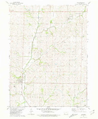
1981 Map of Coin
USGS Topo · Published 1981About this map
Tarkio River and its tributary Tarkio Creek define the drainage of this Page County landscape, where agriculture and rail history intersect. The town of Coin serves as a primary hub, situated along the Norfolk and Western Railroad. Evidence of changing transportation patterns is visible in the Old Railroad Grade that cuts across the northern townships of Tarkio and Nodaway, passing through the small community of Yorktown.
Find a feature on this map
23 named features on this map. Tap any name to fly to it.
Don’t see what you’re looking for? This feature index may not catch every label — zoom into the map to look around manually.
Map Details
Editions of this 1981 Coin Map
This is the sole edition of this map. No revisions or reprints were ever made.
Other maps of this area

1939 · Farragut
USGS Topo · 1:62,500

1940 · Farragut
USGS Topo · 1:62,500

1940 · Coin
USGS Topo · 1:62,500

1943 · Coin
USGS Topo · 1:62,500

1955 · Nebraska City
USGS Topo · 1:250,000

1957 · Nebraska City
USGS Topo · 1:250,000

1958 · Nebraska City
USGS Topo · 1:250,000

1978 · Shenandoah East
USGS Topo · 1:24,000

1978 · Stanton SW
USGS Topo · 1:24,000

1978 · Clarinda North
USGS Topo · 1:24,000