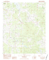
1983 Map of Coker Lake
USGS Topo · Published 1983About this map
Cossar State Park and the northeastern reaches of Enid Lake anchor this 1980s landscape in Yalobusha County, where the terrain transitions from managed state recreation areas into the protected woods of the Holly Springs National Forest. A notable diagonal line marks the Indian Treaty Boundary, a historical dividing line that still influences the property boundaries and road alignments today. Scattered throughout the hills and creek bottoms are numerous small community landmarks, including Robinson Chapel, Philadelphia Ch, and Zion Grove Ch. The area is characterized by a dense network of water bodies, from the larger Chestnut Lake and Coker Lake to the meandering Tillatoba Creek. Genealogists will find a high concentration of burial sites, such as the Fords Well Cem, Salem Cem, and Sayles Cem, which serve as quiet markers of the region's rural settlement history.
Find a feature on this map
35 named features on this map. Tap any name to fly to it.
Don’t see what you’re looking for? This feature index may not catch every label — zoom into the map to look around manually.
Map Details
Editions of this 1983 Coker Lake Map
This is the sole edition of this map. No revisions or reprints were ever made.
Other maps of this area

1953 · West Point
USGS Topo · 1:250,000

1954 · Grenada
USGS Topo · 1:62,500

1954 · Oakland
USGS Topo · 1:62,500

1954 · Water Valley
USGS Topo · 1:62,500

1954 · Water Valley West
USGS Topo · 1:24,000

1955 · Water Valley
USGS Topo · 1:62,500

1955 · Coffeeville
USGS Topo · 1:62,500

1956 · Tupelo
USGS Topo · 1:250,000

1958 · Tupelo
USGS Topo · 1:250,000

1958 · West Point
USGS Topo · 1:250,000