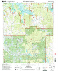
2000 Map of Coker Lake
USGS Topo · Published 2003About this map
Enid Lake dominates the northern landscape of this Yalobusha County survey, where the controlled waters of the reservoir reach into Bean Creek and Long Branch. The map documents a rural Mississippi territory transitioning between the public recreation of Cossar State Park and the preserved timberlands of the Holly Springs National Forest. A network of small family and community cemeteries, such as Sardis Cem, Fords Well Cem, and Sayles Cem, are scattered across the terrain, marking the sites of generational homesteads. Several small lakes including Coker Lake, Swearingen Lake, and Chestnut Lake dot the forest, while local spiritual life is anchored by country churches like Robinson Chapel and Zion Grove Ch. The presence of the Reservation Boundary along the lakefront indicates the intersection of federal water management and local forestry.
Find a feature on this map
32 named features on this map. Tap any name to fly to it.
Don’t see what you’re looking for? This feature index may not catch every label — zoom into the map to look around manually.
Map Details
Editions of this 2000 Coker Lake Map
This is the sole edition of this map. No revisions or reprints were ever made.
Other maps of this area

1953 · West Point
USGS Topo · 1:250,000

1954 · Grenada
USGS Topo · 1:62,500

1954 · Oakland
USGS Topo · 1:62,500

1954 · Water Valley
USGS Topo · 1:62,500

1954 · Water Valley West
USGS Topo · 1:24,000

1955 · Water Valley
USGS Topo · 1:62,500

1955 · Coffeeville
USGS Topo · 1:62,500

1956 · Tupelo
USGS Topo · 1:250,000

1958 · Tupelo
USGS Topo · 1:250,000

1958 · West Point
USGS Topo · 1:250,000