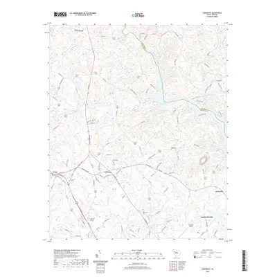
2020 Map of Cokesbury
USGS Topo · Published 2020About this map
Cokesbury serves as a central focal point for this survey of the South Carolina Piedmont, where historical education and rural settlement patterns converge. The presence of Allen University highlights the area's institutional significance, while the landscape is dotted with generational landmarks like Old Tabernacle Cem and the Greenwood Memorial Gardens. To the north, the Saluda River and Reedy River feed into the northern reaches of Lake Greenwood, a major hydrological feature that defines the local topography and borders the line between LaureNS and Greenwood counties.
Find a feature on this map
105 named features on this map. Tap any name to fly to it.
Don’t see what you’re looking for? This feature index may not catch every label — zoom into the map to look around manually.
Map Details
Editions of this 2020 Cokesbury Map
This is the sole edition of this map. No revisions or reprints were ever made.
Other maps of this area

1892 · Abbeville
USGS Topo · 1:125,000

1948 · Abbeville East
USGS Topo · 1:24,000

1949 · Ninety-Six
USGS Topo · 1:24,000

1949 · Greenwood
USGS Topo · 1:24,000

1950 · Abbeville East
USGS Topo · 1:24,000

1954 · Greenville
USGS Topo · 1:250,000

1958 · Greenville
USGS Topo · 1:250,000
1971 · Cokesbury
USGS Topo · 1:24,000
1971 · Ware Shoals East
USGS Topo · 1:24,000
1971 · Laurens South
USGS Topo · 1:24,000