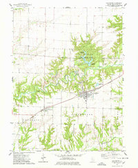
1974 Map of Colchester
USGS Topo · Published 1978About this map
Colchester and the nearby village of Tennessee anchor this mid-1970s landscape, which is defined by a distinct transition from flat prairie farmland to the heavily eroded drainage basins of the East Fork La Moine River. The area reveals a significant industrial heritage centered on geology, with several Quarries, Claypits, and Kilns located north of the primary settlements, particularly around the river bends. This intersection of industry and nature is further emphasized by the presence of Argyle Lake State Park, featuring facilities like the University Point Campground and Campers Hill Campground. Genealogists will find several burial grounds across the townships of Hire, Emmet, and Chalmers, including Mt Auburn Cemetery, Moore Cem, and the Sacred Heart Cem near Pearl Camp. The Burlington Northern railroad runs parallel to the main highway, connecting these rural hubs during a period of established local infrastructure.
Find a feature on this map
33 named features on this map. Tap any name to fly to it.
Don’t see what you’re looking for? This feature index may not catch every label — zoom into the map to look around manually.
Map Details
Editions of this 1974 Colchester Map
This is the sole edition of this map. No revisions or reprints were ever made.
Other maps of this area

1912 · Macomb
USGS Topo · 1:62,500

1913 · Colchester
USGS Topo · 1:62,500

1914 · Macomb
USGS Topo · 1:62,500

1916 · Good Hope
USGS Topo · 1:62,500

1918 · La Harpe
USGS Topo · 1:62,500

1918 · Good Hope
USGS Topo · 1:62,500

1958 · Burlington
USGS Topo · 1:250,000

1961 · Burlington
USGS Topo · 1:250,000

1963 · Burlington
USGS Topo · 1:250,000
1974 · Doddsville
USGS Topo · 1:24,000