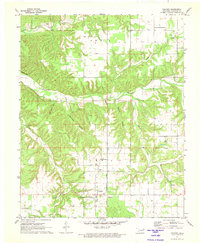
1971 Map of Colcord
USGS Topo · Published 1973About this map
The town of Colcord sits at the southern edge of this 1971 topographic landscape, defined by the winding drainages of the Ozark foothills. This survey captures a rural landscape where narrow hollows like Beartoter Hollow and Crazy Nance Hollow slice through the terrain, feeding into the wider valley of Spavinaw Creek. Settlement patterns here are tied to these watercourses and the local ridges, such as the prominent Eagles Bluff overlooking the western bends of the creek. Genealogists will find a significant concentration of family and community burial grounds, including the Oldfield Cem in the north and Sunset Gardens Cem to the south. Local life is further anchored by landmarks like Bethel Ch and Piney Ch, reflecting a deeply rooted community structure in Delaware County during the early 1970s.
Find a feature on this map
24 named features on this map. Tap any name to fly to it.
Don’t see what you’re looking for? This feature index may not catch every label — zoom into the map to look around manually.
Map Details
Editions of this 1971 Colcord Map
This is the sole edition of this map. No revisions or reprints were ever made.
Other maps of this area

1899 · Siloam Springs
USGS Topo · 1:125,000

1903 · Siloam Springs
USGS Topo · 1:125,000

1904 · Siloam Springs
USGS Topo · 1:125,000

1954 · Tulsa
USGS Topo · 1:250,000

1958 · Tulsa
USGS Topo · 1:250,000

1963 · Tulsa
USGS Topo · 1:250,000

1971 · Jay SE
USGS Topo · 1:24,000
1971 · Jay
USGS Topo · 1:24,000
1971 · Sycamore
USGS Topo · 1:24,000
1971 · Cherokee City
USGS Topo · 1:24,000