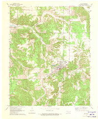
1971 Map of Jay
USGS Topo · Published 1973About this map
The Delaware County seat of Jay serves as the focal point for this early 1970s survey, showing the town's expansion toward the Roadside Park and the municipal Sewage Disp Ponds. To the northwest, the fingers of Lake O' the Cherokees reach into the landscape near the small settlement of Zena, marking the transition from upland terrain to the Grand Lake reservoir system. The topographic data captures a network of creeks and hollows, including the winding Muskrat and Drowning drainages. For local history, the map provides precise locations for several rural landmarks such as the Lookout Tower and Round Spring Ch. Significant genealogical value is found in the scattered burial grounds, including Duffield Memorial Cem and Jumper Cem, which are situated among the intricate ridges and valleys of the Round Spring Hollow region.
Find a feature on this map
21 named features on this map. Tap any name to fly to it.
Don’t see what you’re looking for? This feature index may not catch every label — zoom into the map to look around manually.
Map Details
Editions of this 1971 Jay Map
2 editions found
Other maps of this area

1899 · Siloam Springs
USGS Topo · 1:125,000

1903 · Siloam Springs
USGS Topo · 1:125,000

1904 · Siloam Springs
USGS Topo · 1:125,000

1907 · Wyandotte
USGS Topo · 1:125,000

1909 · Wyandotte
USGS Topo · 1:125,000

1954 · Tulsa
USGS Topo · 1:250,000

1958 · Tulsa
USGS Topo · 1:250,000

1963 · Tulsa
USGS Topo · 1:250,000

1964 · Dodge
USGS Topo · 1:24,000

1971 · Kenwood
USGS Topo · 1:24,000