
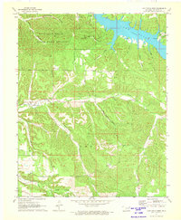
1971 Map of Kenwood
USGS Topo · Published 1972About this map
Spavinaw Hills State Game Refuge dominates the northwestern portion of this 1971 survey, reflecting Oklahoma's mid-century conservation efforts. The settlement of Kenwood sits along the southern edge of the hills, where the landscape transitions into a complex system of drainage hollows. To the northeast, the waters of Lake Eucha are visible, accompanied by a dedicated Campground and the Old Eucha Cem. The terrain is deeply dissected by local drainages such as Salina Creek, Gatcatcher Hollow, and Soldier Hollow. For genealogists and local historians, the map documents several burial sites including Welsh Cem and a general Cem label. Transportation and infrastructure of the era are noted via a Landing Strip and a Radio Tower, while the Refuge Headquarters serves as a primary landmark within the state game lands.
Find a feature on this map
22 named features on this map. Tap any name to fly to it.
Don’t see what you’re looking for? This feature index may not catch every label — zoom into the map to look around manually.
Map Details
Editions of this 1971 Kenwood Map
2 editions found
Other maps of this area

1896 · Pryor
USGS Topo · 1:125,000

1899 · Siloam Springs
USGS Topo · 1:125,000

1901 · Pryor
USGS Topo · 1:125,000

1903 · Siloam Springs
USGS Topo · 1:125,000

1904 · Siloam Springs
USGS Topo · 1:125,000

1954 · Tulsa
USGS Topo · 1:250,000

1958 · Tulsa
USGS Topo · 1:250,000

1963 · Tulsa
USGS Topo · 1:250,000

1971 · Jay SE
USGS Topo · 1:24,000
1971 · Jay
USGS Topo · 1:24,000