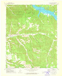
1971 Map of Lake Eucha West
USGS Topo · Published 1973About this map
Spavinaw Hills State Game Refuge dominates the northwestern portion of this 1971 survey, showcasing a landscape defined by the winding drainages of the Spavinaw Hills. The terrain is characterized by a series of named hollows, such as Groundhog Hollow, Fairview Hollow, and Big Acorn Hollow, which feed into the wider systems of Saline Creek and the fingers of Lake Eucha. The settlement of Kenwood is positioned near the center-west, while the Old Eucha Cem remains visible near the lakeshore, a significant landmark for those tracing the history of local communities before the inundation of the reservoir.
Find a feature on this map
29 named features on this map. Tap any name to fly to it.
Don’t see what you’re looking for? This feature index may not catch every label — zoom into the map to look around manually.
Map Details
Editions of this 1971 Lake Eucha West Map
2 editions found
Other maps of this area

1896 · Pryor
USGS Topo · 1:125,000

1899 · Siloam Springs
USGS Topo · 1:125,000

1901 · Pryor
USGS Topo · 1:125,000

1903 · Siloam Springs
USGS Topo · 1:125,000

1904 · Siloam Springs
USGS Topo · 1:125,000

1954 · Tulsa
USGS Topo · 1:250,000

1958 · Tulsa
USGS Topo · 1:250,000

1963 · Tulsa
USGS Topo · 1:250,000

1971 · Kenwood
USGS Topo · 1:24,000

1971 · Jay SE
USGS Topo · 1:24,000