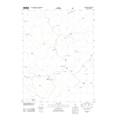
2012 Map of Cold Fork
USGS Topo · Published 2012About this map
Cold Fork serves as a central landmark in this California landscape, where numerous family-named homesteads and seasonal camps are scattered throughout the drainage basins of S Fork Cottonwood Cr and Stinking Cr. The map documents a rural pattern of development marked by specific locales like Skinner Mill Place and Shackleford Place, alongside historical activity centers such as Schoolhouse Flat. High-elevation landmarks like Salt Creek Peak and Stevenson Peak provide a topographical frame for a network of mountain roads, including Weemasoul Rd and Pettyjohn Rd. The survey also notes distinct natural features used for navigation or stock, such as Kingsley Glades, Salt Lick, and the curiously named Hole in the Ground. This 2012 record preserves the placement of isolated holdings like El Rancho Rio Frio and Goat Camp within the sprawling terrain of Tehama County.
Find a feature on this map
52 named features on this map. Tap any name to fly to it.
Don’t see what you’re looking for? This feature index may not catch every label — zoom into the map to look around manually.
Map Details
Editions of this 2012 Cold Fork Map
This is the sole edition of this map. No revisions or reprints were ever made.
Other maps of this area

1890 · Red Bluff
USGS Topo · 1:250,000

1894 · Red Bluff
USGS Topo · 1:250,000

1949 · Colyear Springs
USGS Topo · 1:62,500

1951 · Chanchelulla Peak
USGS Topo · 1:62,500

1952 · Ono
USGS Topo · 1:62,500

1954 · Yolla Bolly
USGS Topo · 1:62,500

1957 · Colyear Springs
USGS Topo · 1:62,500

1958 · Redding
USGS Topo · 1:250,000
1967 · Cold Fork
USGS Topo · 1:24,000
1967 · Oxbow Bridge
USGS Topo · 1:24,000