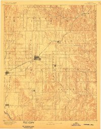
1892 Map of Coldwater
USGS Topo · Published 1900About this map
Coldwater serves as the central hub in this late nineteenth-century survey of Comanche County, where the iron rails of the Atchison Topeka and Santa Fe R. R. cut a diagonal path across the High Plains landscape. The map illustrates a transitional era of settlement, capturing small townships like Protection, Wilmore, and Belvidere as they appeared shortly after the initial prairie expansion. The drainage patterns of the Cimarron River in the southwest and the Medicine Lodge River in the northeast define the undulating terrain, which is subdivided into numerous named survey districts such as Glick, Logan, and Powell. Genealogists and local historians can trace the early township grid and identify the specific placement of rural centers like Nescatunga, Avilla, and Evansville, many of which were vital community anchors for early ranching and farming families before modern road networks evolved.
Find a feature on this map
32 named features on this map. Tap any name to fly to it.
Don’t see what you’re looking for? This feature index may not catch every label — zoom into the map to look around manually.
Map Details
Editions of this 1892 Coldwater Map
5 editions found
Other maps of this area

1889 · Kinsley
USGS Topo · 1:125,000

1891 · Medicine Lodge
USGS Topo · 1:125,000

1892 · Kinsley
USGS Topo · 1:125,000

1892 · Spearville
USGS Topo · 1:125,000

1892 · Coldwater
USGS Topo · 1:125,000

1892 · Pratt
USGS Topo · 1:125,000

1893 · Medicine Lodge
USGS Topo · 1:125,000

1894 · Spearville
USGS Topo · 1:125,000

1894 · Kinsley
USGS Topo · 1:125,000

1894 · Pratt
USGS Topo · 1:125,000