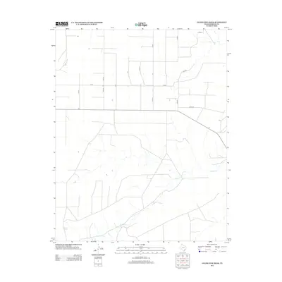
2012 Map of Coldwater Creek
USGS Topo · Published 2012About this map
Coldwater Springs serves as a vital hydrological marker in this northern Texas Panhandle landscape, where the seasonal flow of Coldwater Cr carves distinct drainages through the high plains. The agricultural character of Sherman County is clearly defined by a rigid grid of county thoroughfares, including Co Road L and Co Road M, which segment the terrain into large ranching or farming plots. This 2012 survey by the U.S. Geological Survey illustrates the intersection of modern infrastructure with natural water sources, showing how road networks like Co Rd 28 and Co Rd 30 navigate the winding course of the creek. The map provides a detailed view of the rural homesteads and isolated structures that define life in this sparsely populated region near the Oklahoma border.
Find a feature on this map
10 named features on this map. Tap any name to fly to it.
Don’t see what you’re looking for? This feature index may not catch every label — zoom into the map to look around manually.
Map Details
Editions of this 2012 Coldwater Creek Map
This is the sole edition of this map. No revisions or reprints were ever made.
Other maps of this area

1954 · Perryton
USGS Topo · 1:250,000

1958 · Perryton
USGS Topo · 1:250,000

1974 · Sunray 1 NW
USGS Topo · 1:24,000

1974 · Texhoma South
USGS Topo · 1:24,000

1974 · Stevens SE
USGS Topo · 1:24,000

1974 · Sunray 1 SW
USGS Topo · 1:24,000

1974 · Sunray 1 SE
USGS Topo · 1:24,000

1974 · Capps Switch NW
USGS Topo · 1:24,000
1974 · Pleasure Pond
USGS Topo · 1:24,000

1974 · Hannas Draw West
USGS Topo · 1:24,000