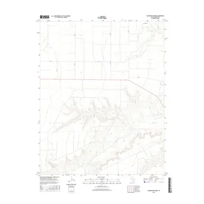
2016 Map of Coldwater Creek
USGS Topo · Published 2016About this map
Coldwater Cr carves a deep, winding canyon through the high plains of the Texas Panhandle in this portion of Sherman County. The drainage is the primary topographical feature of the area, creating a complex network of draws and breaks that contrast with the flat agricultural tablelands above. The presence of Coldwater Springs in the southwest corner indicates a vital historical water source for this semi-arid region. A regular grid of section roads, including Co Rd L and Co Rd 25, provides access to the surrounding farm and ranch land. This document reveals the intersection of natural hydrology and the rectilinear land management patterns common to the Llano Estacado, where roads like Mitchell Rd and Co Rd M skirt the edges of the canyon system.
Find a feature on this map
9 named features on this map. Tap any name to fly to it.
Don’t see what you’re looking for? This feature index may not catch every label — zoom into the map to look around manually.
Map Details
Editions of this 2016 Coldwater Creek Map
This is the sole edition of this map. No revisions or reprints were ever made.
Other maps of this area

1954 · Perryton
USGS Topo · 1:250,000

1958 · Perryton
USGS Topo · 1:250,000

1974 · Sunray 1 NW
USGS Topo · 1:24,000

1974 · Texhoma South
USGS Topo · 1:24,000

1974 · Stevens SE
USGS Topo · 1:24,000

1974 · Sunray 1 SW
USGS Topo · 1:24,000

1974 · Sunray 1 SE
USGS Topo · 1:24,000

1974 · Capps Switch NW
USGS Topo · 1:24,000
1974 · Pleasure Pond
USGS Topo · 1:24,000

1974 · Hannas Draw West
USGS Topo · 1:24,000