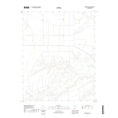
2019 Map of Coldwater Creek
USGS Topo · Published 2019About this map
Coldwater Cr carves a deep, winding path through the High Plains of Sherman County, creating a stark contrast between the flat upland agricultural sections and the eroded breaks of the stream valley. The drainage basin is a significant hydrological marker in this part of the Texas Panhandle, punctuated by Coldwater Springs in the southwest. A rigid grid of county roads, including Co Rd 26 and Co Rd L, overlays the landscape, stopping abruptly at the canyon edges where the terrain becomes too steep for standard section-line travel. This 2019 survey shows the persistence of large-scale land divisions and the reliance on a few primary arteries like Mitchell Rd and Co Rd M to traverse the northern and eastern reaches of the quadrangle.
Find a feature on this map
9 named features on this map. Tap any name to fly to it.
Don’t see what you’re looking for? This feature index may not catch every label — zoom into the map to look around manually.
Map Details
Editions of this 2019 Coldwater Creek Map
This is the sole edition of this map. No revisions or reprints were ever made.
Other maps of this area

1954 · Perryton
USGS Topo · 1:250,000

1958 · Perryton
USGS Topo · 1:250,000

1974 · Sunray 1 NW
USGS Topo · 1:24,000

1974 · Texhoma South
USGS Topo · 1:24,000

1974 · Stevens SE
USGS Topo · 1:24,000

1974 · Sunray 1 SW
USGS Topo · 1:24,000

1974 · Sunray 1 SE
USGS Topo · 1:24,000

1974 · Capps Switch NW
USGS Topo · 1:24,000
1974 · Pleasure Pond
USGS Topo · 1:24,000

1974 · Hannas Draw West
USGS Topo · 1:24,000