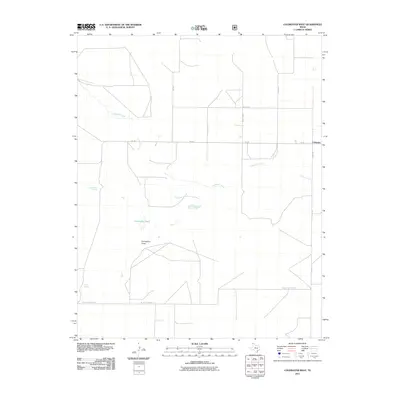
2011 Map of Coldwater West
USGS Topo · Published 2011About this map
Coldwater sits at the eastern edge of this High Plains landscape, a settlement defined by the vital water sources of the Texas Panhandle. The winding course of Coldwater Creek moves across the quadrangle, punctuated by scattered water features like Coldwater Lakes and isolated springs such as Government Spring and Potato Spring. These natural features were historically critical for cattle ranching and early travelers in a region where surface water is sparse.
Find a feature on this map
14 named features on this map. Tap any name to fly to it.
Don’t see what you’re looking for? This feature index may not catch every label — zoom into the map to look around manually.
Map Details
Editions of this 2011 Coldwater West Map
This is the sole edition of this map. No revisions or reprints were ever made.
Other maps of this area

1954 · Dalhart
USGS Topo · 1:250,000

1958 · Dalhart
USGS Topo · 1:250,000

1962 · Dalhart
USGS Topo · 1:250,000

1969 · Boise City SW
USGS Topo · 1:24,000

1969 · Felt
USGS Topo · 1:24,000

1969 · Boise City SE
USGS Topo · 1:24,000

1973 · Buffalo Springs
USGS Topo · 1:24,000

1973 · Tovrea Ranch
USGS Topo · 1:24,000

1973 · Perico
USGS Topo · 1:24,000
1973 · Coldwater West
USGS Topo · 1:24,000