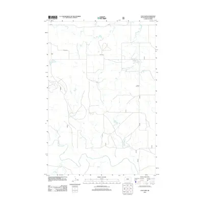
2012 Map of Cole Dam
USGS Topo · Published 2012About this map
Pleasant Valley Cem stands as a quiet marker of local history in this rural corner of Perkins County, where the plains are defined by the winding paths of the Grand River and the S Fork Grand River. The landscape is etched with the drainage patterns of Hay Cr, illustrating the hydrological network that sustains this agricultural region. The map highlights the sparse but essential road infrastructure, including Fredlund Rd and 114th St, which connect the isolated homesteads and ranch lands. At the heart of the area is Cole Dam, a central point for local water management. This 2012 survey provides a clear view of the territorial divisions and the enduring reliance on these river systems for the region's livelihood and development.
Find a feature on this map
7 named features on this map. Tap any name to fly to it.
Don’t see what you’re looking for? This feature index may not catch every label — zoom into the map to look around manually.
Map Details
Editions of this 2012 Cole Dam Map
This is the sole edition of this map. No revisions or reprints were ever made.
Other maps of this area

1954 · Lemmon
USGS Topo · 1:250,000

1957 · Lemmon
USGS Topo · 1:250,000

1983 · Grandmas Butte
USGS Topo · 1:24,000

1983 · Lodgepole SE
USGS Topo · 1:24,000

1983 · Square Top Butte
USGS Topo · 1:24,000

1983 · Bison
USGS Topo · 1:24,000

1983 · Cole Dam
USGS Topo · 1:24,000

1983 · Little Nasty Creek
USGS Topo · 1:24,000

1983 · Bison NW
USGS Topo · 1:24,000
1983 · Haynes SW
USGS Topo · 1:24,000