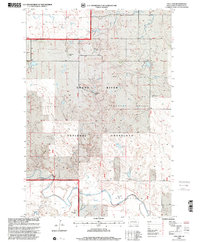
1998 Map of Cole Dam
USGS Topo · Published 2001About this map
Grand River National Grassland dominates this Perkins County landscape, providing a detailed look at the rural ranching operations and water management of the late 20th century. Named family holdings like the J Hedstrom Ranch, J Sandgren Ranch, and C Windhorst Ranch are scattered throughout, illustrating the persistent settlement patterns in this northern plains region. The central geography is defined by the South Fork Grand River and its tributaries, including Hay Creek and Snake Cr. Institutional history is grounded by the Carr Sch, a local Townhall, and the Pleasant Valley Cem. The map highlights unique local landmarks such as Prairie Dog Town and specific recreational points like the Fishing Access near the riverbanks. The survey also marks the Fifth Standard Parallel North, a significant baseline for the Public Land Survey System in this territory.
Find a feature on this map
28 named features on this map. Tap any name to fly to it.
Don’t see what you’re looking for? This feature index may not catch every label — zoom into the map to look around manually.
Map Details
Editions of this 1998 Cole Dam Map
This is the sole edition of this map. No revisions or reprints were ever made.
Other maps of this area

1954 · Lemmon
USGS Topo · 1:250,000

1957 · Lemmon
USGS Topo · 1:250,000

1983 · Grandmas Butte
USGS Topo · 1:24,000

1983 · Lodgepole SE
USGS Topo · 1:24,000

1983 · Square Top Butte
USGS Topo · 1:24,000

1983 · Bison
USGS Topo · 1:24,000

1983 · Cole Dam
USGS Topo · 1:24,000

1983 · Little Nasty Creek
USGS Topo · 1:24,000

1983 · Bison NW
USGS Topo · 1:24,000
1983 · Haynes SW
USGS Topo · 1:24,000