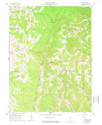
1959 Map of Colebank
USGS Topo · Published 1977About this map
Monongahela National Forest dominates the southern reaches of this landscape, where the rugged terrain of Laurel Mountain and Reno Mountain separates isolated farming and mining communities. This late-1950s record reveals a rural society structured around local education and faith, with numerous small institutions like the Digman Sch, Pifer Sch, and Mt Zion Ch scattered across the ridges.
Find a feature on this map
53 named features on this map. Tap any name to fly to it.
Don’t see what you’re looking for? This feature index may not catch every label — zoom into the map to look around manually.
Map Details
Editions of this 1959 Colebank Map
4 editions found
Other maps of this area

1886 · St. George
USGS Topo · 1:125,000

1891 · St. George
USGS Topo · 1:125,000

1907 · Thornton
USGS Topo · 1:62,500

1907 · Kingwood
USGS Topo · 1:62,500

1907 · Belington
USGS Topo · 1:62,500

1908 · Parsons
USGS Topo · 1:62,500

1925 · Kingwood
USGS Topo · 1:62,500

1926 · Thornton
USGS Topo · 1:62,500

1926 · Parsons
USGS Topo · 1:62,500

1927 · Belington
USGS Topo · 1:62,500