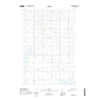
2018 Map of Coleharbor NE
USGS Topo · Published 2018About this map
First German Cemetery is a prominent historical marker in the southwestern portion of this prairie landscape, serving as a reminder of the early European settlement patterns in McLean County. The terrain is characterized by a high concentration of prairie potholes and wetlands typical of the Missouri Coteau region. Large bodies of water such as Audubon Lake in the west and Crooked Lake and Lake Nettie in the southeast dominate the hydrography, reflecting the post-dam landscape of the mid-20th century. The rural road network, including Co Hwy 6 and Co Hwy 8, follows the rigid section lines of the Public Land Survey System, which organized these townships into a predictable grid for agricultural development. Small ponds and seasonal wetlands dot nearly every section, showing the intricate natural drainage that defines this part of the North Dakota plains.
Find a feature on this map
23 named features on this map. Tap any name to fly to it.
Don’t see what you’re looking for? This feature index may not catch every label — zoom into the map to look around manually.
Map Details
Editions of this 2018 Coleharbor NE Map
This is the sole edition of this map. No revisions or reprints were ever made.
Other maps of this area

1929 · Coleharbor
USGS Topo · 1:62,500

1929 · Benedict
USGS Topo · 1:62,500

1929 · Kongsberg
USGS Topo · 1:62,500

1947 · Turtle Lake
USGS Topo · 1:62,500

1954 · McClusky
USGS Topo · 1:250,000

1958 · McClusky
USGS Topo · 1:250,000

1961 · Turtle Lake
USGS Topo · 1:24,000

1961 · Lake Nettie
USGS Topo · 1:24,000
1972 · Coleharbor
USGS Topo · 1:24,000

1974 · Benedict SE
USGS Topo · 1:24,000