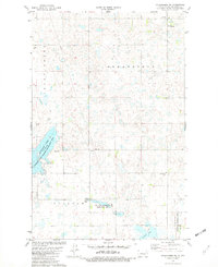
1981 Map of Coleharbor NE
USGS Topo · Published 1982About this map
Greatstone and the surrounding plains of McLean County are defined by a complex landscape of wetlands and water management systems in the early 1980s. The map captures the significant ecological footprint of the Audubon State Wildlife Management Area and the Lake Nettie National Wildlife Refuge, reflecting a region dedicated to conservation and waterfowl habitat. The northern reaches of Audubon Lake dominate the southwestern corner, while Snake Creek meanders through the western section. Local social and religious life is anchored at the Greatstone Ch and the Greatstone Community Cem. The presence of both a Townhall and a separate Community Hall indicates a dispersed but organized rural population. Scattered gravel pits and fencelines reveal the intersection of local industry and agriculture within this protected prairie pothole region.
Find a feature on this map
14 named features on this map. Tap any name to fly to it.
Don’t see what you’re looking for? This feature index may not catch every label — zoom into the map to look around manually.
Map Details
Editions of this 1981 Coleharbor NE Map
This is the sole edition of this map. No revisions or reprints were ever made.
Other maps of this area

1929 · Coleharbor
USGS Topo · 1:62,500

1929 · Benedict
USGS Topo · 1:62,500

1929 · Kongsberg
USGS Topo · 1:62,500

1947 · Turtle Lake
USGS Topo · 1:62,500

1954 · McClusky
USGS Topo · 1:250,000

1958 · McClusky
USGS Topo · 1:250,000

1961 · Turtle Lake
USGS Topo · 1:24,000

1961 · Lake Nettie
USGS Topo · 1:24,000
1972 · Coleharbor
USGS Topo · 1:24,000

1974 · Benedict SE
USGS Topo · 1:24,000