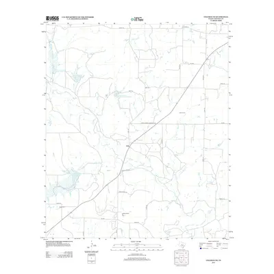
2012 Map of Coleman NE
USGS Topo · Published 2012About this map
Echo sits at the center of this rural landscape in Coleman County, where the transition between traditional ranching and the petroleum industry is clearly visible. The region is defined by an extensive water management system, featuring several large catchments such as the Soil Conservation Service Site 7 Reservoir and Soil Conservation Service Site 25 Reservoir along the winding course of Jim Ned Cr. These reservoirs suggest a concerted effort to manage the local watershed for agricultural and livestock needs. Petroleum extraction remains a core economic driver, evidenced by the broad footprints of the Echo Oil Field and the Eastland Morris Oil Field. For genealogists and local historians, the Walker Cem serves as a vital anchor point for family histories in this part of Texas. The map also traces various natural drainages including Betty Logan Cr and Wilkerson Br, which feed into the larger creek systems.
Find a feature on this map
37 named features on this map. Tap any name to fly to it.
Don’t see what you’re looking for? This feature index may not catch every label — zoom into the map to look around manually.
Map Details
Editions of this 2012 Coleman NE Map
This is the sole edition of this map. No revisions or reprints were ever made.
Other maps of this area

1887 · Coleman
USGS Topo · 1:125,000

1889 · Coleman
USGS Topo · 1:125,000

1924 · Brownwood Reservoir Site
USGS Topo · 1:48,000

1927 · Grosvenor
USGS Topo · 1:62,500

1931 · Baird
USGS Topo · 1:125,000

1932 · Baird
USGS Topo · 1:125,000

1954 · Brownwood
USGS Topo · 1:250,000

1954 · Abilene
USGS Topo · 1:250,000

1958 · Abilene
USGS Topo · 1:250,000

1960 · Lake Scarborough
USGS Topo · 1:24,000