
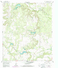
1960 Map of Lake Scarborough
USGS Topo · Published 1962About this map
Indian Creek and its tributaries define the rolling landscape of Coleman County in the early 1960s, a period marked by the critical infrastructure supporting the nearby city of Coleman. The namesake Lake Scarborough sits at the center of the sheet, featuring a clear Spillway and the vital Coleman Filtration Plant at its southern edge. This survey documents the intersection of essential water management and the local aviation and petroleum industries. To the north, Morris Field and a dedicated Landing Strip illustrate the rural transport network, while scattered Oil Wells and a Gravel Pit indicate the active resource extraction of the era. The terrain is deeply incised by drainages like Turtle Bayou, Ned Creek, and Hog Creek, creating distinct geographic markers such as Buck Hollow among the wooded creek bottoms and open pastures.
Find a feature on this map
15 named features on this map. Tap any name to fly to it.
Don’t see what you’re looking for? This feature index may not catch every label — zoom into the map to look around manually.
Map Details
Editions of this 1960 Lake Scarborough Map
2 editions found
Other maps of this area

1887 · Coleman
USGS Topo · 1:125,000

1889 · Coleman
USGS Topo · 1:125,000

1890 · Abilene
USGS Topo · 1:125,000

1892 · Abilene
USGS Topo · 1:125,000

1892 · Ballinger
USGS Topo · 1:125,000

1931 · Baird
USGS Topo · 1:125,000

1932 · Baird
USGS Topo · 1:125,000

1954 · Brownwood
USGS Topo · 1:250,000

1954 · Abilene
USGS Topo · 1:250,000

1958 · Abilene
USGS Topo · 1:250,000