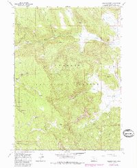
1964 Map of Coleman Point
USGS Topo · Published 1980About this map
Fremont National Forest dominates this high-elevation landscape, where the seasonal movement of water and livestock dictated the map's geography in the mid-1960s. The area is defined by the massive Coleman Rim and the prominence of Coleman Point, creating a natural divide between the northern and southern drainages. Cultural markers like Anderson Ranch and Murphy Ranch suggest a legacy of high-country ranching, while the presence of the Dairy Creek Guard Sta highlights the administrative oversight of these timber and grazing lands. A network of unimproved routes, including the Augur Creek Jeep Trail and Morgan Jeep Trail, provided access to remote locations like Happy Camp and various water sources such as Grasshopper Spring and Eagle Spring. The map also captures early recreational infrastructure at Dairy Creek Campground and Dead Horse Campground.
Find a feature on this map
45 named features on this map. Tap any name to fly to it.
Don’t see what you’re looking for? This feature index may not catch every label — zoom into the map to look around manually.
Map Details
Editions of this 1964 Coleman Point Map
2 editions found
Other maps of this area

1955 · Klamath Falls
USGS Topo · 1:250,000

1958 · Klamath Falls
USGS Topo · 1:250,000

1960 · Fishhole Mtn
USGS Topo · 1:62,500

1964 · Cox Flat
USGS Topo · 1:24,000

1964 · Coleman Point
USGS Topo · 1:24,000

1964 · Cougar Peak
USGS Topo · 1:24,000

1964 · Shoestring Butte
USGS Topo · 1:24,000

1966 · Morgan Butte
USGS Topo · 1:24,000

1966 · Coffeepot Creek
USGS Topo · 1:24,000

1966 · Lee Thomas Crossing
USGS Topo · 1:24,000