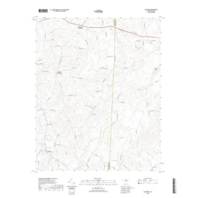
2019 Map of Coleridge
USGS Topo · Published 2019About this map
Coleridge sits along the banks of the Deep River in this detailed survey of southeastern Randolph County. The landscape is defined by the winding paths of Brush Cr and Back Br, which carve through the terrain near family-named landmarks like Sunset Hill. Local history is centered around intersections such as Browns Crossroads and Parks Crossroads, where small clusters of development emerged. Genealogists can identify the Concord Cem and several namesake roads like Kildee Church Rd and Moons Chapel Rd, which point to the long-standing community pillars of the region. The map also captures the Siler City Municipal Airport on the eastern edge, near the Chatham County line, showing the modern infrastructure that connects this rural area to the broader state. The distribution of farms and rural homesteads follows the natural drainage of Reed Cr and Millstone Cr, revealing a settlement pattern rooted in the local topography.
Find a feature on this map
76 named features on this map. Tap any name to fly to it.
Don’t see what you’re looking for? This feature index may not catch every label — zoom into the map to look around manually.
Map Details
Editions of this 2019 Coleridge Map
This is the sole edition of this map. No revisions or reprints were ever made.
Other maps of this area

1953 · Raleigh
USGS Topo · 1:250,000

1954 · Raleigh
USGS Topo · 1:250,000

1968 · Ramseur
USGS Topo · 1:24,000

1968 · Coleridge
USGS Topo · 1:24,000

1968 · Erect
USGS Topo · 1:24,000

1968 · Bennett
USGS Topo · 1:24,000

1969 · Siler City
USGS Topo · 1:24,000

1970 · Bear Creek
USGS Topo · 1:24,000

1974 · Crutchfield Crossroads
USGS Topo · 1:24,000
1974 · Grays Chapel
USGS Topo · 1:24,000