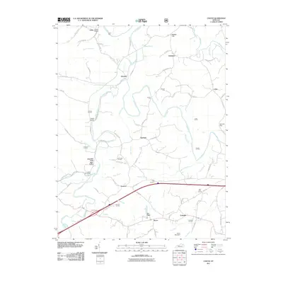
2011 Map of Colfax
USGS Topo · Published 2011About this map
The Licking River carves a winding path through this corner of Bath County, anchoring a landscape defined by small rural settlements and a history of local industry. Along the southern corridor, the map reveals the intersection of transportation and mineral resources, notably at the Ore Mines near Shrout and the Colfax Oil Pool to the east. The presence of Whickliffe Forge Slate Valley and the Prickley Ash Bridge near Slate Creek suggests a legacy of early metalworking and creek-side development. Genealogists will find a dense concentration of family and community burial grounds, including the Old Virginia Cemetery, Goodpaster Cemetery, and Slaty Point Cemetery. From the northern hamlets of Grange City and Stringtown to the southern reach of Polksville, the map preserves the mid-century road network and the enduring topographical landmarks like Devils Nose and Flood Mountain.
Find a feature on this map
93 named features on this map. Tap any name to fly to it.
Don’t see what you’re looking for? This feature index may not catch every label — zoom into the map to look around manually.
Map Details
Editions of this 2011 Colfax Map
This is the sole edition of this map. No revisions or reprints were ever made.
Other maps of this area

1929 · Salt Lick
USGS Topo · 1:62,500

1934 · Salt Lick
USGS Topo · 1:62,500

1951 · Hillsboro
USGS Topo · 1:24,000

1951 · Plummers Landing
USGS Topo · 1:24,000

1952 · Preston
USGS Topo · 1:24,000

1952 · Owingsville
USGS Topo · 1:24,000

1952 · Sherburne
USGS Topo · 1:24,000

1953 · Olympia
USGS Topo · 1:24,000

1953 · Farmers
USGS Topo · 1:24,000
1953 · Salt Lick
USGS Topo · 1:24,000