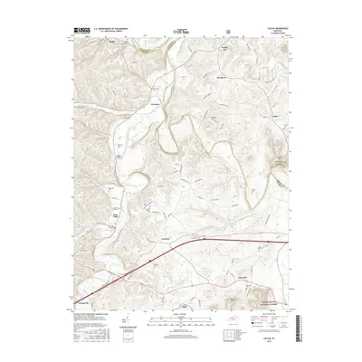
2016 Map of Colfax
USGS Topo · Published 2016About this map
Licking River and its winding tributaries define the landscape of eastern Bath County, where small agricultural settlements are connected by narrow valley roads and timbered ridges. This modern survey captures a region rich in family history, evidenced by numerous burial sites such as Barbers Graveyard, the Old Virginia Cemetery, and the Atchison Cem. The rugged terrain transitions into the Daniel Boone National Forest to the southeast, where Flood Mtn stands above the drainage of Cow Cr. Near the intersection of the Midland Trl and Interstate 64, the community of Owingsville serves as a gateway to the more isolated hamlets of Peasticks and Polksville. Water features like Sportsman Lake and the crossing at Prickley Ash Bridge reflect the local geography that has shaped the area's development since the early frontier era.
Find a feature on this map
105 named features on this map. Tap any name to fly to it.
Don’t see what you’re looking for? This feature index may not catch every label — zoom into the map to look around manually.
Map Details
Editions of this 2016 Colfax Map
This is the sole edition of this map. No revisions or reprints were ever made.
Other maps of this area

1929 · Salt Lick
USGS Topo · 1:62,500

1934 · Salt Lick
USGS Topo · 1:62,500

1951 · Hillsboro
USGS Topo · 1:24,000

1951 · Plummers Landing
USGS Topo · 1:24,000

1952 · Preston
USGS Topo · 1:24,000

1952 · Owingsville
USGS Topo · 1:24,000

1952 · Sherburne
USGS Topo · 1:24,000

1953 · Olympia
USGS Topo · 1:24,000

1953 · Farmers
USGS Topo · 1:24,000
1953 · Salt Lick
USGS Topo · 1:24,000