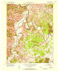
1953 Map of Colfax
USGS Topo · Published 1955About this map
Licking River and Slate Creek dominate this 1950s landscape, carving through the hills of Bath and Fleming Counties. The map reveals a rural economy centered on the river valleys and the Midland Trail, where settlements like Wyoming and Polksville provided local nodes of commerce. Notable for genealogists are the numerous community landmarks, including the Old Virginia Ch and nearby Old Virginia Cem, alongside small rural institutions like Spring Hill Sch and Johnson Sch. The southern portion of the map transitions into the Cumberland National Forest, where the terrain steepens and naming conventions shift to more descriptive local identifiers such as Hog Run and Cow Creek.
Find a feature on this map
47 named features on this map. Tap any name to fly to it.
Don’t see what you’re looking for? This feature index may not catch every label — zoom into the map to look around manually.
Map Details
Editions of this 1953 Colfax Map
This is the sole edition of this map. No revisions or reprints were ever made.
Other maps of this area

1929 · Salt Lick
USGS Topo · 1:62,500

1934 · Salt Lick
USGS Topo · 1:62,500

1951 · Hillsboro
USGS Topo · 1:24,000

1951 · Plummers Landing
USGS Topo · 1:24,000

1952 · Preston
USGS Topo · 1:24,000

1952 · Owingsville
USGS Topo · 1:24,000

1952 · Sherburne
USGS Topo · 1:24,000

1953 · Olympia
USGS Topo · 1:24,000

1953 · Farmers
USGS Topo · 1:24,000
1953 · Salt Lick
USGS Topo · 1:24,000